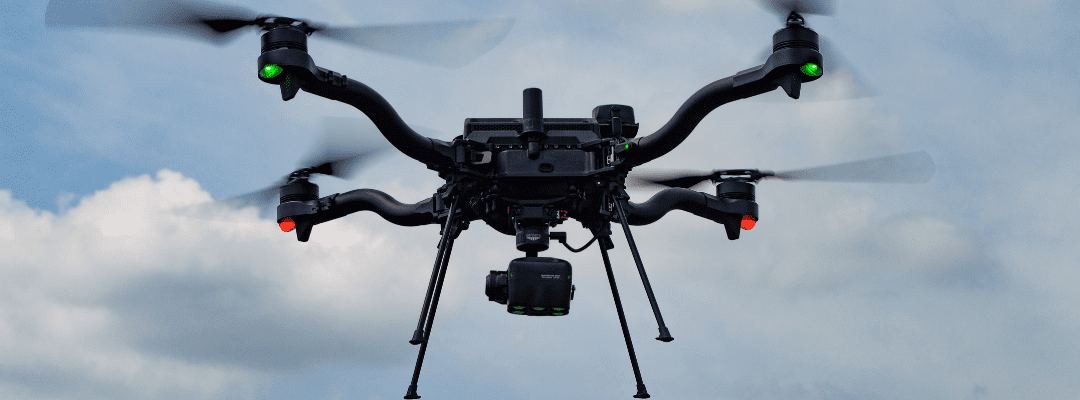
Freefly has become a clear leader in the world of drones, with a history of providing reliable drones with a variety of use cases and providing technology to capture shots that were once deemed impossible.
And, combining Freefly’s leadership in drone technology with Sentera’s deep history in delivering precise and accurate image capture with sensors and an advanced data science ecosystem to translate imagery into analytics makes this combination highly productive in the world of accurate and reliable data capture.
Product Overview: Breaking Down the Hardware
Officially established in 2011, Freefly took the industry by storm with their drone systems and related products.
“Since introducing it in 2021, the Astro has become the drone of choice for our enterprise customers to capture the data they need,” said Matt Isenbarger, chief revenue officer of Freefly Systems. “Over the past decade, our technology has gained a strong reputation in the filmmaking industry, but in recent years we’ve focused on opening our aperture with payload integrations and efficient workflows for other industries – like agriculture.”
The Freefly Astro is a U.S.-made and NDAA-compliant drone that has opened the door for more efficient and reliable data capture. There are several key things that make this drone special for the agricultural market.
“Covering more acres, faster, continues to be a priority for our customers in agriculture,” said Ryan Nelson, chief mechanical engineer, Sentera. “What made us excited about the opportunity to integrate with the Astro was its ability to fly for nearly 40 minutes – and, a high level of confidence and reliability is delivered to ensure maximum flight time and safe charging.”
This is why the Sentera team looked at integrating the Astro with their 6X Multispectral Sensor. The flight endurance of the Astro paired with the fastest-in-class capture rate of the 6X translates to extensive and efficient capture of science-grade multispectral, RGB, and thermal imagery.
“Astro’s plug-and-play technology makes it easy to integrate with the 6X,” said Nelson. “For many of the agronomic leaders that we work with, analyzing data from aerial image capture is where they want to spend their time – so by simplifying how they get into the air, we can unlock some major efficiency and productivity gains.” The system is also equipped with a stabilizing gimbal, which enhances accuracy by ensuring optimal nadir-oriented photo collection and more consistent overlap – reducing the likelihood of gaps in imagery coverage.

Pictured above is Sentera’s 6X’s gimbal
“Combining a precise sensor that captures more imagery faster with a drone system built for endurance, means we can unlock more efficient and effective data capture,” continued Nelson. “Due to highly precise gimbal tuning and aircraft efficiency, pilots can capture more acres in less time – and let’s face it, time is a hot commodity for our customers.”
Get the Shot: Key Use Cases of Freefly’s Astro and Sentera’s 6X Sensor
“On one set of smart batteries, Astro pilots can map over 250 acres – and with the ability to hot swap the batteries, it can make larger automated missions easy,” said Isenbarger. “With this combination, our customers will be able to get deeper and more efficient agronomic insights into their fields.”
The Sentera 6X delivers multispectral imagery that can be used to generate crop health maps and mosaics to understand performance at the plant level, helping to uncover key areas of stress and mitigation strategies. These maps can be generated early in the season, as well as later to understand growth patterns.

And, with Sentera’s advanced data science ecosystem, it can provide a deeper level of insights – starting with insights into emergence across plots with Sentera’s Stand Count and Uniformity analytics.

Above is an example of Male/Female Stand Count analytics
Uncovering the Value and Key Differentiators
The value of the system goes beyond the analytics it can deliver and speaks to data protection and security.
“At Freefly, we value securing customer data and ensuring compliance with the highest standards to demonstrate our commitment,” said Isenbarger. “We worked closely with the Defense Innovation Unit’s (DIU) Blue sUAS 2.0 List project, successfully meeting or exceeding all of the DoD’s tightest security measures.”
In addition, the data captured with this sensor has enhanced data protection as detailed flight logs and drone analytics are all securely stored in Auterion Suite, only when permissioned by the user.
With two U.S. manufacturers partnering together to offer a cohesive solution for the market, it opens the doors for more advanced aerial image capture and analytics delivery in the future.
“We’re excited to offer this solution to customers in the agricultural market,” said Isenbarger. “We look forward to continuing our partnership with Sentera delivering deeper agronomic analytics to improve crop health – and make a positive impact on the future of agriculture.”


